
Background & Area Characteristics
Cobb, Fendley & Associates, Inc. was retained by Southwest Houston Redevelopment Authority / TIRZ #20 to conduct a viability study to improve a segment of Harwin Drive from east of the Gessner intersection to west of the Fondren intersection. This study area is located in TIRZ 20 boundary in Houston, Texas.
The Harwin & Fondren intersection and approaches constructed in late 2016 as part of the Fondren reconstruction from US 59 to Westpark tollway. The Harwin & Gessner intersection and approaches is currently under construction and anticipated to be open to traffic in Summer 2023. CobbFendley was the design engineer for Both projects. The land use along this stretch of Harwin Drive is commercial, retail & wholesale businesses located within TIRZ 20 boundary.
1. Need & Purpose
To improve safety, mobility, and access management in addition to enhanced & ADA compliant pedestrian amenities. Replacement of the existing deteriorating pavement, water utilities, and reconfiguring the travel lanes to optimize vehicular mobility and safety to better serve businesses along the corridor. It is the desire (need) of the Southwest Houston Redevelopment Authority / TIRZ #20 to fund a construction project that will improve traffic operations, safety, pedestrian accommodations, pavement drivability and aesthetics along this segment of Harwin Drive.
2. Existing Conditions
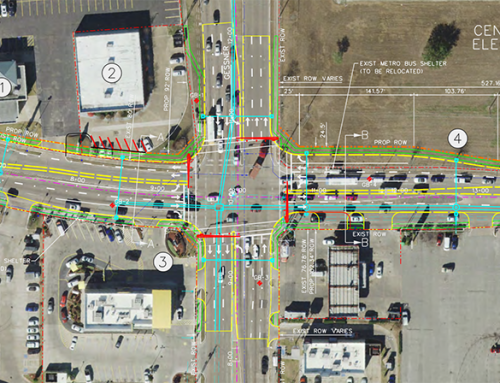
- Existing roadway section is 44’- F-F with 4-lane undivided concrete with curb & gutter roadway and storm sewer system with 11’ lanes between Gessner and Osage. The pavement section is 40’ F-F with 4-10’ lanes undivided from Osage to Fondren.
- Existing ROW is 60-ft wide with no building setbacks.
- There are 4’ sidewalks along both sides of the road with wheelchair ramps that are not ADA compliant
- METRO bus stops for bus routes 152 and 153 along the corridor.
- Storm sewer drainage system which outfalls into an existing 2,200 LF concrete lined channel west of Fondren which flows east under Fondren via 10’x6’ RCB storm sewer trunk system.
- Study area is predominantly retail shopping centers and store fronts commercial corridor.
- The posted speed limit is 35 mph and there are no turn bays to provide safe access to the businesses along the corridor.
- 1 (one) traffic signal at Allday intersection (aging span wire)
- General pavement rideability condition is poor and most panels have been damaged in their entirety
- Existing pavement markings have been either faded and/or inconsistent
- There is street lighting along the corridor
- Existing utilities observed within the project limits:
- Storm Sewer
- Wastewater
- Water
- Gas
- Overhead power
- Communication
3. Alternatives typical sections Recommended: (See attached Typical Sections)
1. 3-Lanes (one travel lane in each direction and 2-way center turn lane), Road diet, which reduces the number of vehicular travel lanes from 4-lanes undivided to a 3-lanes option requiring very little or no ROW acquisition
2. 3-Lanes typical section with bus turnouts/bus pullouts at the current METRO stops along the route requiring 10 strips of 100’x5’ ROW strips to be acquired
3. 4-lane divided boulevard requiring 20-ft additional ROW from 35 parcels to widen the ROW from 60-ft to 80-ft
4. Typical section alternatives comparison:
- Alt1 – Road diet from 4-lane undivided to 3-lane section. (1 travel lane each direction & a 2WCTL within the exist. 60-ft ROW) no impact to the property owners along the corridor
- Alt 2- Same as ALT 1 with multiple bus pull-outs at METRO STOPS requiring 5 – 5’x100’ ROW strips and 1-6’X120’ strip. Minimal ROW impact to the property owners to provide added safety for the METRO bus riders and reduction of vehicular conflicts (bypassing the busses using the center turn lane) & delays behind the bus at the stops
- Alt 3 – 4-lane divided Blvd. section. (2-11’ lanes in each direction and 14’ raised median) expanding the ROW width from existing 60-ft to proposed 80-ft. This will require acquisition of 20-ft additional ROW from 32 parcels. Maximum impacts to the property owners and businesses along the corridor particularly the storefront businesses which may lose their parking; however, it is the safest alternatives by eliminating vehicular conflict points and providing improved pedestrian safety & mobility.
5. Typical section alternatives Analysis:
For Level of Service Comparison, the 4-lane divided boulevard section would operate the best since it has two lanes in each direction along with exclusive left turn lanes. However, this is not feasible due to significant impacts to property owners along the corridor. There would be many businesses that would have to close their doors.
This leaves the other two alternatives to be considered. From an operational standpoint, they will be about the same since there is not a significant number of buses along the corridor. Due to property impacts, the option without the bus pullouts would be the best benefit to the corridor.
The existing condition is a 4-lane undivided section. Due to the driveway density, the two inside lanes currently operate mainly as left turn lanes. This operation causes substantial delays and creates unsafe turning movements. The outside lanes are the only thru lanes that move consistently.
Per the Federal Highway Administration (FHWA) it was determined that four-lane to three-lane Road Diet conversions reduce the total number of crashes by 19 to 47 percent. Several features of a Road Diet contribute to this safety improvement including:
- A reduction in the number of through lanes can calm traffic, reduce weaving, reduce the number of lanes for pedestrians to cross, and reduce left-turn conflicts.
- A two-way left-turn lane (TWLTL) may reduce head-on crashes by dividing opposing traffic and reduce rear-end crashes by providing left-turning vehicles their own lane.
The proposed 3-lane section is expected to operate at a similar average speed as is existing, will not impact businesses, will reduce conflict points and addresses corridor safety which is critical given that this segment of Harwin is on the City of Houston High Injury Network.
6. Preferred Alternative
Alternative 1 – (3-lane section. (1 travel lane each direction & a 2WCTL) requiring no additional ROW.
7. Estimated Construction Cost estimate:
$16 Million (Compiled January 2023)
8. Funding:
Southwest Houston Redevelopment Authority/TIRZ 20 CIP will fund the design, construction and ROW acquisition costs in its entirety.
9. Project Timeline / Anticipated Schedule:
The Preliminary Engineering has recently been completed January 2023
Plan Production and Bid Ready Construction documents anticipated December 2023
Advertising & bidding anticipated January 2024- March 2024
Construction Duration anticipated 18 months
Open to traffic anticipated Fall 2025

